Tuesday, December 19, 2017

EO4GEO: Z_GIS partner of Erasmus+ sector skills alliance project on education and training in the space/geospatial sector

Source: ESA/ATG medialab
Starting with January 2018, 26 partners from 16 countries - including Z_GIS/University of Salzburg - and initially 22 associated partners will collaborate in the the new EO4GEO project, which is focusing on education and training in the space/gesopatial sector.

EO4GEO - Towards an innovative strategy for skills development and capacity building in the space geo-information sector supporting Copernicus user uptake is coordinated by the GISIG association and will run for four years.

The project aims at bridging the skills gap between supply and demand of education and training in the space/geospatial sector. The collaboration partners are focusing on reinforcing the existing ecosystem and fostering the uptake and integration of space/geospatial data and services in end-user-applications.

EO4GEO is an Erasmus+ sector skills alliance gathering partners from the education/training and space/geospatial sectors . Most of the partners from academia, private and public sector are part of the Copernicus Academy Network. The project has been approved by the EU Education, Audiovisual and Culture Executive Agency (EACEA). 

Find more information here: Copernicus news, GISIG association 
Contact: Stefan Lang, Barbara Hofer 

Monday, December 4, 2017

"Shifting approaches to landslides" - LIDAR and American Surveyor magazines report on landslide research activites at Z_GIS

The LIDAR Magazine highlights the landslide research activities at Z_GIS in its October/November 2017 issue. The cover story “Shifting approaches to landslides
reports on the development and application of object-based image analysis (OBIA) methods for semi-automated landslide mapping using optical and SAR remote sensing data. Both the complexities in efficiently and accurately identifying, mapping and inventorying landslides as well as the potentials of powerful methods such as OBIA coupled with results from synthetic aperture radar interferometry (InSAR) are described and discussed.

Quotations from Daniel Hölbling are exemplified by several examples from his and his colleagues’ research on landslides in Taiwan, New Zealand and Iceland, including field photos from past field trips. The article also emphasizes the ongoing research carried out in the MORPH (Mapping, Monitoring and Modelling the Spatio-Temporal Dynamics of Land Surface Morphology) project.

The article by freelance writer Mary Jo Wagner was compiled based on interviews with and material provided by Daniel Hölbling, who coordinates the landslide related research at Z_GIS. The story was also published in the November issue of the American Surveyor Magazine.

Contact: Daniel Hölbling

Sunday, December 3, 2017

Z_GIS Invited to ERASMUS+ Conference in Myanmar!

Z_GIS was invited to the Regional Conference on Cooperation in Higher Education organized by the European Commission's offices in Brussels and Myanmar on 29th and 30th November, 2017 in Yangon. The main aim of the conference was to foster cooperation among various Higher Education Institutions (HEIs) in Europe and the ASEAN region (especially from Myanmar, Laos, Thailand and Vietnam) as well as motivate the ASEAN HEIs to apply for various types of projects within the ERASMUS+ framework. Altogether, the conference attracted about 150 participantsk.

(Conference participants)

The conference was adorned by high level delegates, i.e. Mr. Kristian Schmidt (Ambassador of the European Union to Myanmar), H.E. Prof. Dr. Myo Thein Gyi (Myanmar Union Minister for Education), Ms. Milvia van RIJ-BRIZZI (Head of Department - Erasmus+ & EU Aid Volunteers, European Commission, Brussels), a large number of Rectors, Vice Rectors and Professors from various HEIs in the region.

Dr. Shahnawaz represented Z_GIS in the conference and gave a presentation about an ongoing ERASMUS+ KA2 project 'GeoServices-4-Sustainability (GeoS4S)'. The organisers also asked him to lead a group of the participants from various HEIs aspiring to submit a project proposal. He explained to them various steps from designing an innovative project idea to developing a competitive project proposal and submitting complete documents. Later he was invited for a meeting at the Department of Geography, University of Yangon for exploring the opportunities of cooperation with Z_GIS.

The conference concluded with the demonstration of a lot of enthusiasm and motivation for enhancing cooperation among the HEIs in Europe and ASEAN.

Friday, December 1, 2017

Danubius Young Scientist Award 2017 to Z_GIS researcher Sebastian d'Oleire-Oltmanns

Z_GIS researcher Sebastian d’Oleire-Oltmanns has received the Danubius Young Scientist Award 2017 at a ceremony at the University of Zagreb, Croatia. Congratulations!

The approach, which was provided by the awardee together with the EC Joint Research Center (JRC), aimed to apply and transfer the S3 benchmarking tool. The method should enable EU regions to identify its competitive advantages through systematic comparison with other regions. It was developed as part of the McIndicator project which is coordinated by Z_GIS researcher Stefan Kienberger.

The annual Danubius Young Scientist Award seeks to highlight the scientific work and talent of young researchers and enhance the visibility of the scientific community in the region. Moreover, the award encourages young scientists to engage themselves in the scientific examination of the multifaceted issues and questions specifically related to the Danube Region.


Contact: Sebastian d’Oleire-Oltmanns

More information on the McIndicator project:

Thursday, November 30, 2017

Climate smart coffee and cocoa: PhD focusing on GeoCitizen platform to train farmers and to connect them to new markets

The context of climate smart coffee and cacao is in the focus of a PhD carried out by Mona Bartling (supervisor: Prof. Thomas Blaschke). The PhD topic is based on the BMZ (German Federal Ministry for Economic Cooperation and Development) funded project “Climate smart coffee and cacao: from theory to practice” (CSCC), carried out from January 2017 until December 2019. The CSCC project seeks to improve coffee farmers’ income level while increasing the coffee systems resilience against climate change by mainstreaming climate-smart adaptation and mitigation practices.

Capacity will be built throughout the sector to deliver site-specific information by using the GeoFarmer application which is based on the GeoCitizen platform. These ICT tools will be further developed and used for ‘real-time’ delivery and monitoring of Climate Smart Agriculture (CSA) package implementation, collection of feedback from all actors and in all stages of the project.

The GeoCitizen platform is the English version of the Bürgercockpit application which is being further developed by the Z_GIS spin-off Spatial Services. Therefore, the enhancement of ICT tools within this project is of use not only to the GeoFarmer application, but all derived application versions of the GeoCitizen platform.

In her PhD Mona Bartling focuses on improving the usability of these ICT platforms by studying the implementation of gamification elements for enabling a higher level of participation, in particular of marginalised user groups with a low level of digital literacy. Partnering institutes in this project are the International Center for Tropical Agriculture (CIAT) and the International Institute of Tropical Agriculture (IITA). 

Contact: Mona Bartling

Wednesday, November 22, 2017

2nd place to Z_GIS graduates and team at first EU Datathon

©2017 EU Open Data Portal
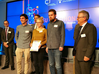
Z_GIS graduates Jakob Miksch and Martin Sudmanns (who is now part the scientific team at Z_GIS) and their colleague Karina Krampf got second place at the first EU Datathon in Brussels for their web application LightOnEurope. Congratulations!

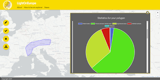
Web application LightOnEurope
The web application allows users to explore any region within Europe by simply drawing it on the map – regardless of administrative boundaries. Based on the user-defined region, the app renders an infographic which conveys relevant and easy to comprehend information on it. Currently, open data on population, landcover, mountains and climate are included. An extension with other datasets such as infrastructure and lakes, but also real-time information on the weather, etc. is envisaged. The app aims to support citizens in exploring regions and in understanding their spatio-temporal dynamics. It is also relevant for other domains such as tourism and transportation and it supports enterprises in finding attractive business sites.

The EU Datathon 2017 – Reusing European Union open data for jobs and growth – EU Open Data Portal Datathon was jointly organised by the Estonian Presidency of the Council of the European Union and the Publications Office of the European Union.

Presenting the LightOnEurope app, the jury emphasised the use of geospatial location to combine datasets across the borders of EU states – an approach which is familiar to the team as all three members are geographers.

More information and news on the app - including the launching date - is available on Twitter and the LightOnEurope-Website. For more information on the app take a look at the presentation and the demo video.

Contact: lightoneureope@gmx.de


Monday, November 20, 2017

GIS Day: Gaining insight into the world of Geoinformatics

About 100 pupils  and 40 teachers from a variety of high schools from Salzburg and Upper Austria  attended the 2017 GIS Day event at the Z_GIS iDEAS:lab to explore geospatial technologies and  applications. After an initial talk on "Location as interface – geomedia in the 21st century" by Robert Vogler a wide range of topics and tools was presented and tested by the participants: sensors and smart buildings, microsimulations, learning with geomedia and rightwing extremism and geomedia, to name just a few.

The attendees actively participated in the programme, such as a group of pupils who shared its experience with the GI Learner programme. Some teachers attended the event in the course of a teacher in-service training.

More information on GIS Day Salzburg
Contact: Robert Vogler

Friday, November 17, 2017

FamoS project: Bicycle models as a planning tool for reorganization of the transport infrastructure

Cities are known as complex, densely populated environments with transport infrastructure playing a substantial role. With a new policy push to shift people’s travel behavior to healthy mobility, improved cycling routes may positively alter the comfort of travelers. A model of traffic flow can help city planners to delineate spots where road rearrangement is required. By means of a simulation approach the model can imitate disaggregated movements of a very large amount of travelers in a spatio-temporal manner. Characteristics of a built bicycle network and a natural environment influence the choice of every individual to use their preferred transport mode and route within a day. Thus, dynamic assignment of people’s daily activity schedules depends on a combination of their personal attributes, along with environmental conditions and interactions. These assumptions in transport modelling are supported by an agent-based approach, which allow unpredictable patterns to emerge. 
The FFG funded FamoS project develops such a bicycle traffic flow model for the city of Salzburg in the GAMA-platform simulation environment, using the agent-based modelling approach. A project partner, the Institute of Highway Engineering and Transport Planning from the Technical University of Graz, implements a classical 4-step transport modelling technique to develop a similar bicycle demand model for Graz.

Contact: Martin Loidl,  Interfaculty Department of Geoinformatics  - Z_GIS


Thursday, November 16, 2017

Z_GIS team awarded 3rd place at the European Copernicus Masters University Challenge

Congratulations to Martin Sudmanns, Hannah Augustin, Christian Werner, Anna-Maria Cavallaro, Dirk Tiede and Stefan Lang! The Z_GIS researchers developed and submitted a web-application to the Copernicus Masters University Challenge 2017.

The tool aims to improve the conceptualisation, planning and feasibility assessment of earth observation (EO) projects by providing information about the suitability of data for known project specifications. Projects utilising European Sentinel satellite data can be approached more efficiently, saving time and initial planning costs. The tool will also aid less experienced users of EO-data towards more efficient and targeted project planning and execution.

The interactive Web-based tool visualises and analyses the metadata of the 2+ million currently accessible Sentinel-2 images, revealing spatio-temporal variability of acquisitions that inherently influence analyses. It allows querying spatially explicit aggregated information, such as average cloud cover, average time span between scene acquisitions, time gap between cloud-free scenes, etc. Analytical maps explore specific themes (e.g. cloud cover) improving the identification of suitable study areas, or retrieval of Sentinel-2 imagery for a use-case with specific data characteristics.

For example, a project team might be interested in monitoring deforestation in Indonesia based on change detection using a time-series. With the tool, the users can select an area-of-interest and immediately retrieve relevant information about the frequency of acquisition, historic information of the average time between cloud-free acquisitions, etc.

Contact: Martin Sudmanns 

Sunday, November 12, 2017

Excellence Award for Z_GIS' Dr.Shahnawaz

Dr. Shahnawaz has been has been honoured with the ‘Excellency Award 2017’ by the Union of Geographic Information Technologists (UGIT) established at Bangalore University, India for his contributions in enhancing geospatial education, training and research in South and Southeast Asia over last fifteen years. He is Director of UNIGIS S/E Asia at the Interfaculty Department of Geoinformatics - Z_GIS, University of Salzburg, Austria and has established cooperations for Geospatial education between Z_GIS and a number of leading universities in S/E Asia and implemented a range of cooperation activities.

Dr. A. S. Kiran Kumar, Chairman - Indian Space Research Organisation conferred the award on Dr. Shahnawaz in Bangalore during the inaugural session of the 6th UGIT’s International Conference on Climate Change and Sustainable Water Resource Management – Innovative Geospatial Solutions schedule from November 9 to 11, 2017.

Congratulations!

Saturday, October 28, 2017

ASEA Uninet Workshop 'clim-SAT' in Bogor, Indonesia

The Department of Geoinformatics - Z_GIS implemented a week-long Interdisciplinary Faculty Development Workshop on 'Geospatial Applications of Satellite Generated Atmospheric and Climatic Data (clim-SAT)' at Bogor Agricultural University (IPB), Bogor, Indonesia. The workshop was organised jointly by Z_GIS and IPB from 23rd to 27th October, 2017. The clim-SAT project was co-funded by ASEA Uninet Austria.

The workshop was inaugurated by Dr. (Ms) Sri Nurdiati, Dean - Faculty of Mathematics and Natural Sciences, IPB. The session was followed by three open lectures delivered by Prof. Lilik Budi Prasetyo and Prof. I. Nengah Surati Jaya both from Faculty of Forestry, IPB; and Dr. Shahnawaz from Z_GIS which attracted about 100 attendees from within and outside the IPB.

(Attendees in the clim-SAT inaugural session) 

Dr. Shahnawaz (Z_GIS) and Dr. (Ms) Imas S. Sitanggang (IPB) conducted the workshop at the Faculty of Forestry (IPB). They taught the participants about the TERRA, AQUA, TRMM and GPM satellite platforms as well as trained them in using a range of data sets generated by various sensors aboard these platforms. Focusing on an interdisciplinary approach, 25 teachers and postgraduate students from 9 universities across 4 countries (i.e. Indonesia, Malaysia, Philippines and Thailand) participated in the workshop. The trainees worked on individual projects and explored geospatial applications of various atmospheric and climatic data sets in a range of disciplines. The hands-on practical work was based on the GIS software ArcGIS Desktop, and all participants presented interesting outcomes in the concluding seminar. The workshop concluded with a visit to the Indonesian National Institute of Aeronautics and Space (LAPAN) on the last day.

(Clim-SAT Workshop Participants) 

Prof. Lilik Budi Prasetyo (Head, Dept. of Forestry, IPB) conferred the certificates of successful completion on the participants and congratulated them for having benefitted from this international and interdisciplinary workshop. Appreciating the high quality of the workshop, he announced that IPB has allocated 3 credits to the workload for recognising it as a part of various study programmes at IPB as well as other participating universities. He also conveyed his gratitude to Z_GIS as well as to ASEA Uninet and expressed willingness to strengthen and expand the institutional collaboration with Z_GIS.

Friday, October 20, 2017

MORPH project: First field trip to Iceland

During a field trip to Iceland this summer, the MORPH team visited the study sites around Hekla and Öræfajökull. The MORPH project (Mapping, Monitoring and Modelling the Spatio-Temporal Dynamics of Land Surface Morphology) focuses on the investigation of landslides and volcanic deposits in these two study areas in Iceland. Both areas are highly dynamic in their geomorphic evolution and characterised by progressive mass displacements and surface deformation.  

Daniel Hölbling, Barbara Friedl and Jirathana Dittrich collected field pictures, took GPS measurements and validated preliminary analysis results in the field. They presented first results for selected study areas and discussed them with the collaboration partners from the University of Iceland in Reykjavik and with local experts from the South East Iceland Nature Research Center (NATTSA) in Höfn.   

The study areas are of high complexity in their environmental, geological and geomorphological conditions. Visiting the sites made the researchers more familiar with the specific conditions. The field trip complemented and improved the remote sensing based analysis. 
 

Wednesday, October 18, 2017

SemEO project nearing its completion

The FFG-ICT of the Future exploratory project SemEO (Semantic enrichment of optical Earth observation data to enhance spatio-temporal querying capabilities) is nearing its completion at the end of October.
The main outcome is a prototypical architecture of an innovative EO semantic querying subsystem together with a fully automated EO image understanding subsystem.
The system allows semantic content-based querying of images and spatio-temporal analyses directly in the database, which is not possible in current state-of-the-art EO image retrieval systems (like the Copernicus Open Access Hub). The proposed system contributes to the big data paradigm to ‘bring the user to the data and not the data to the user’, and to the ability of users to retrieve valuable information otherwise hidden in big EO data archives.

For more information on the project see the recent GEO Blog post: Automatic Semantic Enrichment for Intelligent Big Earth Observation Databases

Contact: Dirk Tiede

Tuesday, October 17, 2017

Weekend dedicated to EO for humanitarian action: Z_GIS and Spatial Services GmbH delivering information products for Rohingya crisis and presenting collaboration with MSF at political discourse

A high-level political discourse under the overall topic “Smart me, smart home, smart world” took place at the Evangelische Akademie in Tutzing on 13-15 Oct, where Stefan Lang (Z_GIS) and Edith Rogenhofer (MSF Austria) presented the fruitful and long-lasting collaboration between Z_GIS and Doctors Without Borders (Médicins sans Frontières, MSF).
© Louise Annaud/MSF

In their dual talk, insights were given on how satellite technology is being used by MSF for logistics support, aid and food delivery, vaccination campaigns, and more. 
Emphasis was placed on the fact, that relying on recent technology such as Earth observation satellite data and image analysis to support strategic decisions in humanitarian action, implies mutual trust building among partner institutions. Issues were discussed on data sharing, data security, reliability of products, and the resulting decisions process.

© Z_GIS/MSF
Simultaneously to the workshop attendance, Z_GIS supported by Spatial Services GmbH, delivered first hand information products for the current Rohingya crisis in Bangladesh over the weekend. The information was used to better plan aid measures by the epidemiologist team on the ground.

More information / Contact: Stefan Lang


Thursday, October 12, 2017

Knotenpunkt für IKT: Salzburgs Landeshauptmann besucht Z_GIS als Teil der wachsenden Science:City in Salzburg-Itzling

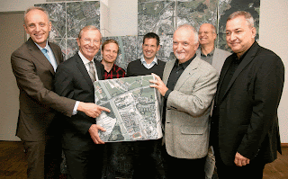
LH Haslauer (2.v.l.) im iDEAS:lab (© Salzburg Research/wildbild)
Salzburgs Landeshauptmann Dr. Wilfried Haslauer war zu Gast bei Z_GIS im Techno-Z. Im iDEAS:lab bekam er einige Schwerpunkte unserer Forschungsaktivitäten zu sehen: Das Team des GI Mobility Lab präsentierte aktuelle Projekte für eine klima- und umweltfreundliche Mobilitäts- und Regionalplanung. Das vorgestellte Projekt GISMO zeigt, welchen gesundheitlichen Nutzen Pendler haben, wenn sie für ihren Weg in die Arbeit auf das Fahrrad umsteigen oder zu Fuß gehen, und welche Möglichkeiten geographisch differenzierte Maßnahmen für ein betriebliches Mobilitätsmanagement bieten. Darüber hinaus bekam er einen Einblick in die Beobachtung von Klimawandel-Indikatoren im alpinen Raum und konnte sehen, wie wir mithilfe satellitengestützter Fernerkundung humanitäre Hilfsorganisationen bei ihrer Arbeit in Krisengebieten unterstützen.

Neben diesen und anderen Forschungsinitiativen steht Z_GIS auch bei informatisch-technisch orientierten Studien im Mittelpunkt: das internationale Masterstudium Geoinformatik hat die höchste Anzahl an Absolventen mit dahingehender Ausrichtung und ist damit ein wichtiger Faktor für die Technologie-orientierte Unternehmenslandschaft in und um Salzburg.

Z_GIS ist Teil der Science:City Itzling. Der Standort, an dem neben Z_GIS u.a. auch das Center for Human Computer Interaction der Universität Salzburg sowie die Salzburg Research Forschungsgesellschaft angesiedelt sind, hat sich in den letzten Jahren zu einem Zentrum für IKT im Bundesland Salzburg entwickelt. Z_GIS ist seit 2004 an diesem Standort.

Mehr Informationen 

Tuesday, October 10, 2017

Paper development workshop

This 1,5 days workshop, which took place at the end of September 2017 in Salzburg, was organized as a follow-up event of the winter school 2017 held in St. Wolfgang. Around 20 participants, mainly from the Doctoral College “GIScience” and the PhD study programme “Applied Geoinformatics” worked on four different topics such as “Big earth data”, “VGI & Social media for urban context”, “Big trajectories” and “Uncertainty in big geospatial sensor data”.

The idea of the workshop was that each group shall have a clear plan with milestones to develop the research topic / idea of the winter school further via a mini-conference, a final conference and a paper.

The results were presented in a form of a poster and a 5 minutes elevator pitch where all group members were involved. Jury members, consisting of faculty members and young scientists, gave critical feedback and helped the groups to narrow down the topics and to improve the concept.

Although the schedule was very tight during these 1,5 days it was a fantastic and inspiring atmosphere which again strengthened the team spirit.

Friday, October 6, 2017

Satellite Applications for the Alps - Search and Rescue Edition

This year´s conference on "Satellite Applications for the Alps: Search and Rescue Edition" will take place from October 11-12 in Brixen, Italy.

The confernce, entitled IMS "Meet.Mountain.People.Soul", focuses on nature meeting technology. It is dedicated to satellite applications for search and rescue, emergency response, civil protection and risk mapping in and around the Alps, asking: How can satellite communication and navigation enable more advanced emergency call systems? How can it enhance the coordination of teams? How can Earth Observation help to provide better geo-information and post natural disaster imaging?

Z_GIS is again actively involved in the organisation and implementation of this event, together with EURISY, IDM Südtirol, Cluster Satellite Navigation BGL – Salzburg und GI-PLUS e.V., to name just a few.

The two-day event is free.

Find all information on the event online online and take the chance to participate via online registration.


Contact Z_GIS: sebastian.doleire-oltmanns@sbg.ac.at

Wednesday, October 4, 2017

Successful GeoS4S Meeting in Amsterdam, Netherlands

The consortium members of the ‘GeoServices-4-Sustainability' (GeoS4S) project from 10 partner universities located in Europe (4), China (3) and Thailand (3) met at the School of Business and Economics, VU Amsterdam, Amsterdam from 25th to 27th September, 2017 to review project progress at the completion of the second year of the project. The Interfaculty Department of Geoinformatics - Z_GIS, University of Salzburg, Austria serves as coordinator of this project, co-funded by the European Commission under the ERASMUS+ programme from October 2015 to October 2018.

(GeoS4S Members at Year-2 Meeting)

Three major objectives of the GeoS4S project aim at developing teaching/learning resources of 20 modules; to organise International Summer Schools for testing the relevance and operational feasibility of these modules, and to integrate teaching/learning resources on an eLearning platform for open and free access worldwide. The twenty three experts involved in the project gathered to review the progress of the project during years 1 & 2 and to fine tune the activities planned for the final year of the project.

The progress made by various team members was considered highly satisfactory and the enthusiasm for further enhancement of the quality of the deliverables was widely present. Critical assessment of the milestones achieved during the first two years was taken as the guiding principle for streamlining the activities of the final year. It was agreed upon that the consortium members need to perform beyond expectations during the two International Summer Schools to be conducted in China and Germany as well as introducing and discussing high quality teaching/learning materials during the two dissemination conferences planned in China and Thailand. The consortium will conduct a monitoring review in March 2018 during the International Summer School in Nanjing, China.

Hilfe aus nächster Nähe

"Hilfe aus nächster Nähe" nennt sich eine Ausstellung der Hilfsorganisation Ärzte ohne Grenzen (MSF), die von 4.-15.Oktober am Salzburger Mozartplatz zu sehen ist. 
Ärzte ohne Grenzen zeigt den Besuchern, wie humanitäre Nothilfe funktioniert: Was wird für die Errichtung von Wasserversorgung & Sanitäranlagen benötigt und wo macht es am meisten Sinn, diese zu bauen? 
Wie werden Krankheiten wie Cholera behandelt, wie viele Personen müssen geimpft werden und wie gelangen die Medikamente in Krisengebiete?  Wie Satellitenbilder und räumliche Analysen helfen, diese Einsätze effizienter zu planen, zeigt der Fachbereich Geoinformatik - Z_GIS.

Seit mehreren Jahren analysiert der Fachbereich Geoinformatik - Z_GIS Satellitenbilder für die Hilfsorganisation Ärzte ohne Grenzen (MSF) und unterstützt dabei die Helfer vor Ort beim Aufbau und der Organisation von Camps und der Planung von Logistik und Impfkampagnen.

Mit einer Ausstellung am Salzburger Mozartplatz gibt  Ärzte ohne Grenzen Besuchern von 4. - 15. Oktober einen Einblick in seine Arbeit. Z_GIS zeigt am Beispiel des Flüchtlingslagers Nduta in Tansania Auswertungen, die die Arbeit vor Ort unterstützen. Zusätzlich können Besucher einen 360°-Einblick in das Leben in einem Flüchtlingslager bekommen.

Interessierte können dem Z_GIS-Team, das sich auf humanitäre Themen spezialisiert hat, am Freitag, den 6. Oktober, von 14 bis 16 Uhr Fragen stellen, wenn sie die Ausstellung besuchen. Sie erfahren, mit welcher Detailgenauigkeit einzelne Strukturen und Gebäudearten auf Satellitenbildern identifiziert werden können, und welche Analysemethoden das Arbeiten in Krisengebieten unterstützen können.

Mitten in Salzburg. Hilfe aus nächster Nähe. 
Eine Ausstellung von Ärzte ohne Grenzen. 
4.-15. Oktober 2017, täglich von 10 bis 18 Uhr (6.10., 14-16 Uhr: Z_GIS)
Salzburg, Mozartplatz

Eintritt: frei

Friday, September 15, 2017

Johannes Kapser defends his PhD Thesis "Modeling of thermal lifts"

Johannes Kapser, PhD candidate at Z_GIS successfully defended his PhD Thesis “Modelling of Thermal Lift: Techniques for Mining Thermal Eddies from Aerial Movement Data”.

Being a passionate glider pilot Johannes’ research was all centred around the core question “how to model thermal lift based on collectively sensed aerial trajectory data”. Therefore he approached this central research question through three main research themes: thermal lifts, trajectory parameters and patterns, and data-based deterministic and probabilistic modelling.

As one of his major results, Johannes came to the conclusion that there is great potential in the explict geospatial modeling of thermal eddies for better understanding of thermal processes in different environments. The successful modeling of the relation between environmental context and thermals can also accelerate research in the direction of thermal prediction for secure identification of thermal lifts.

A very international audience followed Johannes’ impressive and challenging presentation and actively participated in the lively discussion between after the evaluators, Dr. Josef Strobl and Dr. Robert Marschallinger, both from Z_GIS at the University of Salzburg were satisfied with all their questions. Dr. Thomas Blaschke as the main supervisor acted as the chair. 

Johannes works for a private company in the Munich aerospace industry. We wish him well on his road to a successful career in industrial research!

Wednesday, September 13, 2017

Mobility award for "Urban Emotions" project

VCÖ Mobilitätspreis Salzburg 2017 © Land Salzburg/Mayer
Congratulations to Bernd Resch and the "Urban Emotions" project team! The project was awarded second at this year´s "VCÖ Mobilitätspreis Salzburg". The prize is awarded annually by the Austrian traffic organisation Verkehrsclub Österreich (VCÖ). 

The "Urban Emotions" project aims to establish a more citizen-centric view of urban planning through integrating emotional responses to their environment. Do they feel comfortable or are they scared in underpasses or at traffic hotspots?  

In the interdisciplinary project, Bernd Resch and his team capture information about user´s sensations from human-generated data: 
a) from human sensors: test persons wear sensors (wrist bands or chest belts) which measure physiological parameters, from which emotions and stress levels can be derived 
b) from social media: analysis of publicly accessible data from social networks like Twitter, Facebook , Flickr and Instagram using semi-supervised machine learning algorithms.

The project aims to promote climate-friendly mobility and citizen-centered urban planning. Field studies in Kaiserslautern and in Boston are already concluded. In the aftermath of the project, the city administration of Kaiserslautern already improved the infrastructure and security for its bikers and initiated awareness-building programmes for climate-friendly mobility. The next field study will be conducted in the city of Salzburg.

Tuesday, September 12, 2017

Z_GIS in Tajikistan: GIS in tourism and recreation management

Within the Erasmus+ “International Credit Mobility” programme (KA107), Sabine Hennig (Z_GIS) is currently lecturing and leading workshops and tutorials at RTS University in Dushanbe and subsequently at Khorog State University (Tajikistan).

Focusing on the benefits of applying Web GIS in tourism and  recreation planning and management, she is also providing students with an introduction to GIS and spatial analysis methods.

The KA 107 programme is key to academic mobility with (non-EU) partner countries.

Contact: Sabine Hennig

Monday, September 11, 2017

Successful Conclusion of Erasmus Mundus project 'gSmart'

We invite you to explore the 'gSmart' project's report brochure which provides comprehensive information on the Z_GIS coordinated Erasmus Mundus scholarship mobility project 'gSmart - Spatial ICT Infrastructures for Smart Places'. Today, the Joint Coordinators have submitted the Final Report to the EACEA office in Brussles, the project has been successully concluded on July 14, 2017.

These gSmart scholarships focused on all levels of study, with the anticipation that this study and research mobility will in turn create new job opportunities, contribute to the enhancement of quality in teaching and learning of Geoinformatics as well as advancing research activities in this interdisciplinary domain. Further information on mobility flows provide the scholar's e-portfolios and 'Success Stories'.

This interactive and dynamic maps on gSmart mobilities from Central Asia to Europe are showing all project scholarship mobility flows >>  http://arcg.is/1sEBB5H.


gSmart at a Glance
2013 – 2017, Erasmus Mundus funded mobility scholarship project for Central Asian students and staff. 106 reported scholarships. Bachelor to PhD and Post-Doc levels, and Faculty. Short visits as well as completion of full degree programs. 6 partner universities in Europe. 13 Central Asian Higher Education Institutions. State of the art education in Geoinformatics.

Barbara Brunner-Maresch, University of Salzburg, Department of Geoinformatics - Z_GIS, gSmart Project Coordinator, http://em-gsmart.zgis.net

Thursday, September 7, 2017

Erasmus+ Mobility in the KA107 Program

KA107 - this sounds like a mysterious code providing secret access to something highly desirable, and it is exactly that: this EU programme is key to academic mobility with (non-EU) partner countries.

Z_GIS has a long tradition of facilitating (predominantly) incoming mobility by students and faculty. More than 100 mobility scholarships were the core element of the recently completed gSmart project, and play an important role in the current GeoS4S initiative.

The ongoing KA107 scheme is entirely focussed on academic mobility, with Z_GIS successfully participating with our partner institutions across a wide range of partner countries: these include the Central Asian republics of Kyrgyzstan, Tajikistan and Uzbekistan as well as Bhutan, Nepal, India, Thailand, China, New Zealand and Australia.

Prof Josef Strobl, Head of Department @Z_GIS states: "We are looking forward to welcome programme participants from universities in these countries and expect them to enrich the international character of our department as well as study programmes, and vice versa take home valuable knowledge, experiences and friendships."

From a broader perspective, Paris-Lodron University Salzburg (PLUS) clearly is a leading university in cooperation with partners worldwide. Compared to other Austrian Higher Education Institutions, PLUS within KA107 organizes a dominant share of Austrian student and faculty mobilities with partner institutions in Africa, Asia and Latin America.

Through highly rated and successful applications within the Erasmus+ 'International Credit Mobility' (KA107) program PLUS already has secured 1.6 million Euro in funding, available to attract excellent students and faculty from leading institutions worldwide, as well as opening doors for Salzburg students and academics at these partners.

"This raises the international visibility of Salzburg, increasingly being recognized not only as a cultural highlight, but also as an academic hub for higher learning and cutting-edge research" says Peter Mayr, Director for International Relations.

For details regarding International Credit Mobility (KA107) funding across Austrian institutions, please refer to https://bildung.erasmusplus.at/de/hochschulbildung/internationale-mobilitaet/mein-laufendes-projekt.


Sunday, September 3, 2017

agri-HIMAL workshop completed in Nepal.

The GIScience Commission of the Austrian Academy of Sciences, the Interfaculty Department of Geoinformatics - Z_GIS, University of Salzburg, Austria and Tribhuvan University (TU), Kathmandu, Nepal jointly organised a regional workshop on 'GIScience Assessing the Feasibility of Agricultural Diversification in the Himalayas (agri-HIMAL)' in Kathmandu, Nepal from 27 to 31 August, 2017.

 (agri-HIMAL organisers and participants at the workshop conclusion)

Dr. Shahnawaz (Z_GIS) and Prof. Krishna Poudel (CDE) coordinated this workshop hosted by the Central Department of Education (CED-TU). The Eurasia-Pacific Uninet (EPU), the event brought together 23 teachers, students and practitioners from Nepal, Bhutan and Austria.

The opening ceremony attended by the workshop participants and dignitaries from various academic and administrative departments of TU was chaired by Prof. Krishna Prasad Gautam (Dean, Faculty of Education). He expressed appreciation of the ongoing cooperation between the GIScience Commission, Z_GIS and TU as well as conveyed thanks to the EPU for supporting such joint activities. The participants learned about the physical, climatic and socio-economic specifics of the Himalayas through a series of lectures. They did 'hands-on' practical exercises on ArcGIS and MaxEnt software to process and analyse various geospatial datasets for assessing the feasibilities of agricultural diversification in the Himalayas.

The Rector of TU, Prof. (Ms). Sudha Tripathi, conferred the 'certificates of successful completion' on the participants. All participants appreciated the organisation of the workshop and expressed a high level of satisfaction about their learning outcomes within the short period of one week, and envisaged to expand academic cooperation between their respective institutions and Z_GIS.

Tuesday, July 4, 2017

Successful PhD defense of Pablo Cabrera-Barona within the Doctoral College "GIScience"

Pablo Cabrera-Barona, PhD researcher at Z_GIS successfully defended his PhD Thesis “A Multidisciplinary Spatial Framework for Health Inequalities Analysis with Emphasis on Deprivation and Healthcare Accessibility”.

In his research, Pablo focused on the analysis of deprivation and healthcare accessibility, understanding them as integral concepts that incorporate objective and subjective measures, the integration of which enables the representation of multidimensional health-related phenomena. Pablo provided a multidisciplinary spatial framework that uses different mixed-methods approaches to understand health inequalities.

The results showed that the created deprivation indices facilitate the identification of social disadvantages and can support the explanation of health outcomes. It was also shown that the combination of objective measures and perceptions can represent inequalities of multidimensional healthcare accessibility and healthcare satisfaction and that these multidimensional measures can be explained by social factors of human health-related behavior. It could also be demonstrated that area-level features of deprivation and spatial accessibility to healthcare influence individual-level healthcare satisfaction.

Around 30 attendees from 14 different nations listened to Pablo’s impressive presentation which was followed by a fruitful discussion between the evaluators, Dr. Alexis Comber from the University of Leeds and Dr. Stefan Lang from Z_GIS. Dr. Thomas Blaschke as the main supervisor acted as the chair.

We wish Pablo all the best for his future endeavors and career!

Tuesday, June 20, 2017

MAPATHON goes AGIT / GI-Forum

Z_GIS lädt gemeinsam mit Ärzte ohne Grenzen (MSF) und dem Österreichischen Roten Kreuz  zu einem Mapathon in Salzburg ein.

Mapathons sind eingebettet in das Missing Maps Projekt von MSF, dem Roten Kreuz und dem Humanitären Open Street Map Team (HOT OSM) und bieten engagierten Freiwilligen überall auf der Welt eine Plattform, humanitäre Hilfe mit online mapping in Krisenregionen zu unterstützen. Geografische Details, wie Dörfer, Straßen und Infrastruktur werden basierend auf Satellitenbildaufnahmen interpretiert und kartiert, und bieten somit für die Arbeit von Hilfsorganisationen eine wichtige Informationsgrundlage, damit diese im Krisenfall schneller und gezielter reagieren können. Bei diesem Mapathon, der zum ersten Mal im Rahmen der AGIT in Salzburg stattfindet, wird ein Gebiet bearbeitet, das aktuell von Naturkatastrophen, Krankheiten oder Konflikten betroffen ist und in dem sowohl MSF wie auch das Österreichische Rote Kreuz aktive Hilfe leisten.

Wer kann mitmachen?
Jede/r kann mitmachen, egal ob Anfänger/in oder erfahrene Mapper. Mitzubringen ist lediglich ein eigener Laptop (inkl. Maus).

Wann & wo findet der Mapathon statt?
Dienstag,  4. Juli 2017
17 bis 19 Uhr
im Rahmen der AGIT / GI-FORUM 

Achtung: für die Teilnahme am Mapathon muss keine Konferenzgebühr bezahlt werden! Es genügt eine Registrierung im AGIT Tagungsbüro.

Universität Salzburg, Naturwissenschaftliche Fakultät
Dekanatssaal, 1.Stock
Hellbrunnerstrasse 34
5020 Salzburg

Kontakt
Lorenz Wendt
Barbara Riedler

Project X3D4Pop kicked off: Population estimation in urban areas from experimental 3D remote sensing data

How many people live in a city? This seemingly simple question very often arises in the daily work of MSF (Doctors without Borders) or SOS Children’s Villages. Activities like a vaccination campaign or the preparation for natural disasters require up-to-date population figures. With more and more people moving into cities, the sprawling urban areas move more and more into the focus of aid and relief organisations.

Population numbers can be estimated from the number of buildings mapped in remote sensing data, but in urban areas, 3D data is required to account for the building heights. The research project X3D4Pop, which was kicked off in Salzburg in May, aims at exploring the potential of 3D data derived from satellite image pairs initially not acquired for stereo data production, as dedicated stereo image pairs are often missing. Can image pairs from different satellites, acquired at different times, be used to derive building heights?

X3D4Pop brings together experts in photogrammetry from the German Aerospace Center DLR and dasymetric mapping from the Austrian Institute of Technology AIT and the Swiss UNEP/GRID-Geneva, and is led by Z_GIS to further enlarge the portfolio of remote sensing services for humanitarian organisations. X3D4Pop is funded by the Austrian FFG, the Swiss Space Office SSO, and the DLR.

Contact: Lorenz Wendt