Wednesday, September 30, 2015
Z_GIS department outing to the National Park Berchtesgaden
Wednesday, September 23, 2015
UN-SPIDER supports efforts to manage landslide risk in Bhutan. Z_GIS contributes to workshop on risk and vulnerability assessment.
13 participants from stakeholder organisations in Bhutan
attended a training-workshop on landslide risk and vulnerability assessment in Timphu,
Bhutan in August. Stefan Kienberger, Z_GIS, led a practical session and
discussion on landslide risk and vulnerability analysis.
 |
| Stefan Kienberger, Z_GIS, led a practical session and discussion. |
Landslide
is one of the most prominent hazards in Bhutan. The workshop was conducted by
the United Nations Platform for Space-based Information for Disaster Management
and Emergency Response (UN-SPIDER), the United Nations Development Program
(UNDP), the Department of Disaster Management (DDM) and the Ministry of Home
and Cultural Affairs in Bhutan. The capacity
building workshop was conducted as a follow-up to the UN-SPIDER Technical
Advisory Mission (TAM) to Bhutan.
Monday, September 21, 2015
Recommendations for sustainability in the Mondsee area
Hermann
Klug, Z_GIS, presented his recommendations for a sustainable development in the
area around the lake
Mondsee. The team "Frischer Wind für St.
Lorenz” had invited him to an event on September 10, 2015. This is a group of inhabitants of St. Lorenz making determined
efforts on environmental protection and sustainability in the region. About 40
participants were discussing topics such as sustainable agriculture and
forestry, biodiversity and renewable resources.
 |
| Recommendations for a sustainable development in the Mondsee area |
Thursday, September 17, 2015
Science goes public: The Z_GIS Landscape Lab
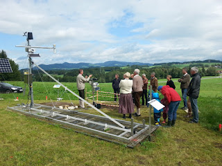
How do scientists measure specific weather characteristics? And what about soil conditions and water parameters? At the autumn festival in Koppl close to Salzburg more than 200 visitors received answers to these questions.
Hermann Klug, project leader of the Z_GIS Landscape Lab in Koppl, offered guided tours through the research field to visitors. He presented the single sensors used for analyzing the changing environmental conditions. The Landscape Lab from a bird´s eye view was another highlight: Sebastian d'Oleire-Oltmanns demonstrated how unmanned aerial vehicles (UAVs) are used for analyzing the terrain from above.
 |
| Hermann Klug, Z_GIS (left), at one of the guided tours through the observation station |
Saturday, September 5, 2015
Summer Hackademy on 3D Rapid Mapping
 During the months of August and September, four University
of Salzburg students are working on a smartphone-based solution for 3D rapid
mapping. In this "Summer Hackademy", the students try to extract a
high-density point cloud from a series of images
from uncalibrated cameras ("Structure from Motion") in a joint effort
at the intersection of Geoinformatics and Computer Science.
During the months of August and September, four University
of Salzburg students are working on a smartphone-based solution for 3D rapid
mapping. In this "Summer Hackademy", the students try to extract a
high-density point cloud from a series of images
from uncalibrated cameras ("Structure from Motion") in a joint effort
at the intersection of Geoinformatics and Computer Science.The highly skilled and ambitious students working on the project are Clemens Havas, Nikolai Janakiev, Jakob Miksch and Salman Muhammad, supervised by Dr. Bernd Resch and Prof. Dr. Thomas Blaschke.
The long-term goal is to develop a system for indoor navigation through the identification of key points in the point cloud by an intelligent fingerprinting algorithm.
Subscribe to:
Posts (Atom)

