Wednesday, December 14, 2016

E2mC project: Integration of Social Media Analysis and Crowdsourced Information within Mapping and Early Warning Components of the Copernicus Emergency Management Service

Current methods in disaster management, which are greatly based on remote sensing technology, suffer from severe shortcomings including a temporal lag of typically 48-72 hours, or limited spatial resolution. The E2mC project aims at demonstrating the technical and operational feasibility of the integration of social media analysis and crowdsourced information within both the Mapping and Early Warning Components of the Copernicus Emergency Management Service (EMS). The project started with a kick-off meeting in Rome last week.

The project team will develop a prototype of a new EMS Service Component (Copernicus Witness), designed to exploit social media analysis and crowdsourcing capabilities to generate a new product of the EMS portfolio.
Heterogeneous social media data streams (Twitter, Flickr, Facebook, Instagram, etc.) will be analysed and sparse crowdsourcing communities will be federated (crisis specific as Tomnod, HOT, SBTF and generic as Crowdcrafting, EpiCollect, etc.).

E2mC will perform demonstrations within realistic and operational scenarios designed by the users involved within the project (Civil Protection Authorities and Humanitarian Aid operators, including their volunteer teams) and by the current Copernicus EMS Operational Service Providers that are part of the E2mC Consortium. The involvement of social media and crowdsourcing communities will foster the engagement of a large number of people in supporting crisis management and increase awareness of Copernicus.

Contact: Bernd Resch 

Tuesday, November 29, 2016

Filip Biljecki awarded the "Young Researcher Award in GIScience"


The Austrian Academy of Sciences' (ÖAW) Commission for GIScience has awarded the “Young Researcher Award in GIScience” to Filip Biljecki, a PhD student at Delft University of Technology, for his outstanding publication achievements in the field of Geographic Information Science and Geoinformatics.

Filip specializes in his research on 3D GIS and city models. In his colloquium talk, Filip introduced current projects of his research group and gave a brief overview of his PhD thesis. He focuses on the level of detail and error propagation in 3D GIS. The research investigates how errors in the reconstruction of 3D building models affect the output of spatial analyses. An approach involving intentionally degraded procedural models was developed, and this technique was applied to estimating the solar irradiation on rooftops.

Although Filip has a deep technical background in 3D data models and representation, some scientists from different research domains of the Department of Geoinformatics - Z_GIS identified common research interests, which may lead to future research collaborations. It was an honor for the Department of Geoinformatics to hand over the award on behalf of the ÖAW to Filip. 

Tuesday, November 22, 2016

Re-Viewing GIS Day 2016

Global GIS Day every year is a wonderful opportunity to invite schools to get in touch with Geoinformatics, experiencing how to bridge the real and virtual worlds. More than 200 pupils from several schools in and around Salzburg visited Z_GIS on Nov 16, working their way through 7 different modules ranging from operating robots to learning about drone aerial photography and managing a safe trip to school by bike.

University of Salzburg Rector Prof Heinrich Schmidinger
speaking at the iDEAS:lab opening during GIS Day 2016

This year's GIS Day was an even more special event due to the opening of our new iDEAS:lab, where schools in the future will have year-round opportunities to learn about spatial technologies and related applications. In addition to functioning as a 'learning lab', this facility simultaneously will serve as a 'research lab', an 'open science lab' a 'transfer lab' in collaboration with our industry partners.

Check out photographic impressions from Nov 16 @Z_GIS > https://flic.kr/s/aHskvoj68P

Monday, November 21, 2016

MORPH project: analysing surface morphology changes


The FWF project MORPH (Mapping, monitoring and modelling the spatio-temporal dynamics of land surface morphology) started at the beginning of November 2016. The project team seeks to develop novel methods for mapping, monitoring and modelling spatial-temporal dynamics of surface morphology including the analysis of various optical and radar remote sensing data.

MORPH focuses on the investigation of landslides and volcanic deposits in two study areas in Iceland, which are highly dynamic in their geomorphic evolution and characterized by progressive mass displacements and surface deformation. One major objective is the development of an efficient object-based image analysis (OBIA) method for the multi-scale mapping of slope instabilities and volcanic deposits. The method aims to be transferable across various sensing data and at the same time automated in order to be able to analyse time series for monitoring spatio-temporal changes of land surface morphology.

The MORPH project benefits from a close collaboration with researchers from the University of Iceland. Daniel Hölbling (Z_GIS) was invited to attend the mid-term workshop of the EMMIRS (Environmental Mapping and Monitoring of Iceland by Remote Sensing) project beginning of November in Iceland. The workshop was an ideal opportunity to share experiences and become familiar with the characteristics and the evolution of the Hekla study site.

Contact: Dirk Tiede, Daniel Hölbling

Saturday, November 19, 2016

Stellenausschreibung: Senior Lecturer

Z_GIS is looking to fill a temp position (50%) at the senior lecturer level, please check the job advert at the official university gazette for details. Application deadline is Dec 7!
https://online.uni-salzburg.at/plus_online/wbMitteilungsblaetter.display?pNr=1839030 (item 26, p. 7 bottom)

For details, please contact Dr Ingrid Ritter

addendum: we have been informed that this position is intended to be filled at a lower level than originally announced, please refer to a later edition of the gazette for a corrected version.

Wednesday, November 16, 2016

Opening of iDEAS:lab - bridging education, research and the public


About 200 visitors: pupils, representatives from the local and regional governments, from industry and University of Salzburg leadership attended today´s opening of the iDEAS:lab - the main highlight of this year´s global GIS Day in Salzburg. The iDEAS:lab ("Integrated Digital Earth Applications and Science Lab"), located at the Techno-Z in Salzburg-Itzling, is a platform for education, research and cooperation with industry and the public.

It serves as a multi-purpose open geospatial technologies and media lab, where visitors can experience, explore and understand Digital Earth technologies. The lab is open to schools, students, researchers and the public. Additionally, it is designed as an industry hub for networking and hosting business events. The aim of the new iDEAS:lab is to provide an engaging, dynamic and innovation-friendly learning environment for geoinformation science.

In the iDEAS:lab, visitors use geo-technologies to explore solutions for their own lives, such as the safest route to school. In addition, the iDEAS:lab will evolve into an interface between geoinformation science and the public, while at the same time serving as a transfer lab for industry.

Recently the iDEAS:lab concept was nominated as a finalist for the Education Award of the B&C Private Foundation.


Contact: Bernd Resch (iDEAS:lab), Robert Vogler (PLUS School of Education)

Tuesday, November 15, 2016

Z_GIS team won first Open Data Copernicus Hackathon

Martin Sudmanns, Hannah Augustin, Christian Werner, Stefan Zimmer and Gina Schwendemann are the winners of the first Open Data Copernicus Hackathon. At the two-day event, which took place in Vienna at the beginning of November, the Z_GIS team designed the "sharecropper app" and developed it as a prototype.

The sharecropper app maps land cover changes detected using Copernicus Sentinel-2 images based on known farmland parcels. These changes are combined with crowd-sourced and open data related to land ownership and land use, creating a global inventory about the type and magnitude of changes.
Participants of the Hackathon in Vienna (image source: INiTS)
At the Hackathon nine international project teams - scientists, developers and data experts - designed applications in the fields of humanitarian action and human security. The Z_GIS team is one of two winners of the event, which was organized by the business incubator INiTS and financially supported by the Austrian Ministry for Transport, Innovation and Technology (bmvit) and the Austrian Research Promotion Agency (FFG).
Z_GIS has been developing Earth-observation (EO) based solutions for the humanitarian sector for several years.

Contact: Martin Sudmanns


Monday, November 14, 2016

First Mapathon for MSF and the Austrian Red Cross in Vienna


On 7 November 2016 a Mapathon, jointly organized by Doctors without Borders (MSF) and the Austrian Red Cross, took place in Vienna. Staff and students from the University of Salzburg/Z_GIS participated together with 25 volunteers to support the Missing Maps project through their mapping in HOT OSM (Humanitarian Open Street Map).

During the 3-hour Mapathon two areas where information is crucial for the work of humanitarian organizations were tackled: in Mwenezi district, Zimbabwe settlements and their main connecting roads were digitized to support the distribution of vaccination and medication supplies of MSF; in Malawi single household-buildings were mapped to strengthen the local Red Cross in their planning and capacity building activities related to disaster response.

Contact: Barbara Riedler, Gina Schwendemann, Stefan Lang, Lorenz Wendt (EO4HumEn+ Project)

Tuesday, November 8, 2016

Satellite Applications for the Alps


Z_GIS participated in the conference “Satellite Applications for the Alps” which took place in Berchtesgaden on 27th October 2016 and was organized by EURISY and WFG Berchtesgadener Land

The conference is part of a biannual series and dealt with different applications derived from or based on satellite communication and data with a special focus on the Alps. Participants from all over Europe (Norway, Denmark, France, Germany, Austria, Italy, Slovenia and more) attended the conference and fostered the interactive exchange between providers, users and experts.

Florian Albrecht acted as expert for environmental monitoring for landslide detection and protection and represented the Land@Slide project currently being carried out at Z_GIS. Sebastian d’Oleire-Oltmanns took over as a moderator to lead a session on Connectivity, Tourist activities, Natural habitats and biodiversity monitoring and preservation. The conference provided a good opportunity to foster Z_GIS’ long term engagement and support of the Copernicus program as well as its user uptake initiatives.

Thursday, October 20, 2016

SemEO project: Semantic enrichment of big earth data

The FFG-ICT of the Future exploratory project SemEO started with a kick-off meeting on October 7, 2016 in Salzburg. The overall goal of SemEO (Semantic enrichment of optical EO data to enhance spatio-temporal querying capabilities) is to investigate conceptual strategies and technical framework conditions to enhance the semantic enrichment of optical EO data. It aims to reach a status allowing human users the querying of EO data on a higher semantic level.

The project strives
(1) To semantically enrich optical EO data to a level of basic land cover classes based on a convergence of evidence approach; (2) To investigate spatio-temporal modelling and querying techniques in semantically enriched EO databases using encoded ontologies; (3) To review and test the usability and scalability of array databases and specific implemented data models (data cubes) for spatio-temporal queries in big image databases;

Background: Big earth data is a challenge for efficient and intelligent storage, analysis and distribution. While for other big data domains the main challenge is the sheer amount of data, satellite data needs conversion into information first to unfold their potential as a source for relevant multi-temporal geoinformation. State-of-the-art EO image retrieval is based on simple metadata text information only (acquisition time, target geographic area, cloud cover estimate), without the possibility of higher semantic content-based querying of images or spatio-temporal image-content extraction. SemEO tackles these limitations and builds upon a novel semantic querying system for content-based image retrieval from multi-source big earth data – a result of the successful FFG-ASAP project AutoSentinel-2/3.

Project lead: Dirk Tiede, Z_GIS

Wednesday, October 12, 2016

PhD defense within the Doctoral College "GIScience"


Yesterday, Ivan Tomljenovic, PhD candidate of the Doctoral College „GIScience“defended successfully his PhD Thesis „Transferable and robust building extraction from airborne laser scanning data using Object-Based Image Analysis Paradigm".

In his thesis Ivan provided a new research approach that employs the Object-based methodology on point cloud data obtained from ALS systems in order to extract tangible information in the form of building outlines. The research focused on the analysis of the point cloud derivatives defined as 2.5D and 2D representations and knowledge modelling in a form or rule set implemented with the Cognitional Network Language (CNL) which is integrated within eCognition software as a framework container. The core results of this thesis clearly show that it is possible to use the object-based methodology in  order to extract building outlines with more than 90 % accuracy.

More than 45 attendess listened to Ivan's impressive presentation which was followed by a fruitful discussion between Ivan and the evaluators, Dr. Stefan Lang from Z_GIS and Dr. Peter Reinartz from the Earth Observation Center in Munich.

We wish Ivan all the best for his future career and endeavours!
 

Saturday, October 8, 2016

ASEA Uninet Workshop 'comm-PLAN' in Chiang Mai, Thailand

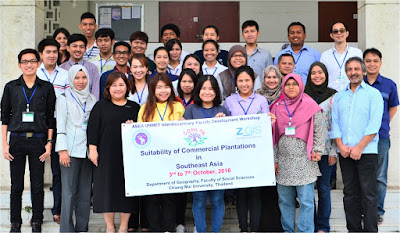
The Department of Geoinformatics - Z_GIS concluded a week-long international capacity building workshop on 'Assessing the Suitability of Commercial Plantations in Southeast Asia (comm-PLAN)' at Chiang Mai University (CMU), Chiang Mai, Thailand. The workshop was organised jointly by Z_GIS with the Department of Geography (D-of-Geog), CMU from October 3-7, 2016 and also included a field excursion for ground truthing on October 7. The comm-PLAN project was co-funded by ASEA Uninet Austria.

 The comm-PLAN participants rejoicing their successful start and completion of the workshop!

Dr. Shahnawaz (Z_GIS) and Dr. Chanida Suwanprasit (D-of-Geog) conducted the workshop at CMU and trained the participants in using various spatial analysis methods ralated to suitability assessment.

Focusing on an interdisciplinary approach, 27 teachers and postgraduate students from 10 universities located in 4 countries (i.e. Indonesia, Malaysia, Philippines and Thailand) participated in the workshop. The trainees worked on individual projects assessing the suitability of a range of commercial plantations in Southeast Asia using ArcGIS Desktop and MaxEnt software. All of them presented interesting outcomes in the concluding session.

Asso. Prof. Dr. Ajchara Wattanapinyo (Head, D-of-Geog) conferred the certificates of successful completion on the workshop participants and congratulated them for having benefited from this international workshop. She also conveyed her gratitude to Z_GIS as well as to ASEA Uninet and expressed their willingness to host more such workshops in the near future.

Wednesday, October 5, 2016

INQUIMUS workshop 2016 in Salzburg


,Spatial and temporal dynamics of risk and vulnerability’ was the topic of the third INQUIMUS workshop. The workshop was successfully held from 21st – 23rd of September 2016 at the Edmundsburg above the old city of Salzburg. The thematic focus of the 2016 workshop was on scenarios relevant for assessments of risks and vulnerabilities.

The scientific committee was made up of members of  Z_GIS, EURAC, the University Ca'Foscari (Venice), the HVRI /University of South Carolina and the United Nations University. The meeting gathered more than 30 participants with a high diversity of different thematic backgrounds as well as profiles from junior to distinguished senior scientists. Discussions and presentations where held in a very interactive way, which define the unique character of INQUIMUS workshops as platform of exchange [link to agenda]. 

The workshop started with an inspirational talk about ‘The futurist from Salzburg - Robert Jungk’ from Stefan Wally of the Robert Jungk Library for Future Studies. State-of-the-art talks were provided by various experts and scientists in the field: Hans-Martin Füssel (European Environment Agency, DK),  Susan Cutter (Univ. of South Carolina, USA), Jasper van Vliet (Vrije University, Institute for Environmental Studies, NL) and Anne Goujon (IIASA, AT). 

A range of posters was presented, including case studies of risk and vulnerability assessments or the development of new indices or data input for scenarios. As a common conclusion, open issues to be addressed in the context of ‘risk and vulnerability scenarios’ were identified.


Contact: Z_GIS: Stefan KienbergerMarkus Kerschbaumer