Tuesday, July 24, 2018

Successful PhD defense of Ovidiu Csillik

Ovidiu Csillik successfully defended his PhD Thesis “Spatio-temporal object-based image analysis for land-use/land-cover mapping”. He started his PhD research in October 2015 within the framework of the Doctoral College “GIScience” and finished his PhD research incredibly fast within 2 years and 10 months.

Ovidiu’s research aimed to develop efficient, fast and accurate OBIA workflows for single and time series satellite images for land-use/land-cover mapping, with a special focus on mapping agriculture. First, he integrated the concept of superpixels into multiresolution segmentation workflows. Subsequently, the incorporation of the temporal domain of the satellite images into the analysis led to the development of object-based workflows for crop mapping from time series of Sentinel-2 satellite images. Finally, an object-based time-constraint dynamic time warping (DTW) workflow was developed in an object-based software environment, the first implementation of DTW in an OBIA framework.
This research has a significant potential to enable automation and objectivity of OBIA workflows for time series data analysis and was documented by six major publications.

Ovidiu will start his Postdoc career at the Department of Global Ecology of Stanford University in the research group of Greg Asner in August 2018.

We wish Ovidiu all the best for his future career and endeavours!

Wednesday, July 18, 2018

GeoS4S International Summer School-3 in Germany!

The consortium of the GeoServices-4-Sustainability (GeoS4S) project consisting of 10 universities from Europe, China and Thailand conducted its 3rd International Summer School (ISS-3) for 2 weeks at Eberswalde University for Sustainable Development (HNEE), Germany from 9th to 20th July, 2018.

Student and Teacher participating in GeoS4S-ISS-3

The GeoS4S-ISS-3 has been designed to enhance geospatial competences of postgraduate level students and young faculty from all the consortium members. The consortium selected 48 participants hailing from 18 nationalities but studying / working at the 10 partner universities in Europe, China and Thailand. The experts from the GeoS4S consortium taught 5 modules during the first week and 5 modules during the second week of the ISS-3 and each module had about 10 participants.

The teachers from the consortium universities taught the concepts and methods of the modules they have developed within GeoS4S framework and trained the participants in implementing those concepts and methods using geospatial data and GIS software.

The Interfaculty Department of Geoinformatics-Z_GIS of the University of Salzburg, Austria serves as project coordinator assisted by co-funding from the European Commission under the Erasmus+ Key Action 2 CBHE (Capacity Building in Higher Education) from October 2015 to October 2018.

This is the last International Summer School planned within GeoS4S project and the consortium will organise two dissemination conferences, one in Thailand and one in China during the next months.

Thursday, July 12, 2018

Sen2Cube.at: Sentinel-2 Semantic Data Cube Austria


On 3 July 2018, the FFG-ASAP project Sen2Cube.at held its kick-off meeting in conjunction with the AGIT/GI_Forum conference in Salzburg.

Aside from the academic partner (University of Salzburg, Z_GIS), the project involves AMA (Agrarmarkt Austria), ZAMG (Zentralanstalt für Meteorologie und Geodynamik) and the university spin-off SpatialServices.

The Sen2Cube.at project will be taking very relevant steps towards building an Austrian data & information cube. It will exemplarily show that semantic content-based image and information retrieval (SCBIR) is possible in big Earth observation (EO) databases. This innovation will allow human users to query and analyse EO data on a higher semantic level (i.e. based on at least basic land cover units and encoded ontologies). Planned tasks include:

  • developing algorithms for systematic and automated semantic enrichment for Sentinel-2 images to reach a semantic level up to land cover types, ready for semantic content based querying
  • identifying suitable database technologies to develop spatio-temporal modelling and querying techniques in semantically enriched EO databases using encoded ontologies to decrease the complexity of queries for human user interaction
  • developing a Web interface for human-like queries based on spatio-temporal relationships and explicitly specifying spatio-temporal models for different envisaged user groups.

The data & information cube is generic, meaning it can be useful for multiple thematic domains. The potential will be demonstrated by developing different services in a generic, proof-of-concept environment for Austria. These services include enabling semantic content-based image retrieval, generating cloud-free mosaics for user-specified time slices and developing an App for location-based queries through time.


Contact: Dirk Tiede, Z_GIS

Thursday, July 5, 2018

Nanjing Normal University <> PLUS dual degree extended


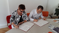
Today we were honoured to welcome Prof HU Minquiang, Chancellor of Nanjing Normal University, for a signing ceremony with PLUS Vice Rector for International Relations, Prof Sylvia Hahn. Based on the renewed cooperation agreement, students from NJNU continue to attend the PLUS Geoinformatics MSc programme with an opportunity to simultaneously earn degrees from both universities.

School of Geographical Science at the Nanjing Normal University > http://schools.njnu.edu.cn/geog/
MSc Applied Geoinformatics @ PLUS > http://msc-agi.zgis.at/ | www.uni-salzburg.at

Monday, July 2, 2018

EO4Alps Summer school


On June 24th the UNIGIS EO4Alps summer school - jointly organized by Z_GIS and GEO - has started. The event is dedicated to the topic “Earth observation and geospatial information: supporting a sustainable use of alpine ecosystems and water resources”. It brings together international students and practitioners from 9 countries and is supported by the European Space Agency (ESA) and the Copernicus Academy. The intense program deals with the key environmental challenges in alpine regions as well as the potential of remote sensing techniques to meet these needs. The combination of international key speakers with hands-on sessions and field trips offers the opportunity to discuss with experts and get first hand experiences. Next week the summer school participants will present their group works in form of posters at the GI_Forum Expo night on Wednesday July 4th.