Showing posts with label DK. Show all posts

Wednesday, March 16, 2022

Successful PhD defense at Z_GIS


Humanitarian aid is becoming increasingly important as ever more emergencies such as natural disasters, wars, and pandemics threaten entire societies across the globe. During these emergencies, timely geospatial information about the event is crucial to enhance situational awareness for humanitarian aid. However, current monitoring approaches often cannot provide sufficient, timely, high-quality results for disaster management. In the case of refugee movements caused by such emergencies, there is often hardly any information available. Addressing and overcoming these limitations is critical for humanitarian aid and can be addressed with available big data.

In his dissertation, entitled
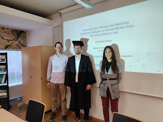
"Semantic and Geospatial Machine Learning Analysis of Social Media Data for Humanitarian Aid"
,  Clemens Havas presented a novel methodology for the analysis of georeferenced social media data, specifically Twitter data, to provide additional information for humanitarian aid. The methodology combined state-of-the-art  machine  learning  methods  (topic modelling and  hot spot  analysis) developed in two different fields, namely natural language processing and geographic information science. Its objective was to extract relevant social media posts within a specified region and period and identify places connected with the analysed event.

Conclusion of this thesis was, that social media analysis can be used as a flexible tool for humanitarian aid and help close the information gap until more data sources emerge and supplement existing findings. Additionally, social media outcomes serve as proxies for real-world geographic phenomena, as shown by comparisons of celled results and actual investigated events.

We wish Clemens all the best for his future career!


Monday, January 4, 2021

Graduate of the DK GIScience voted best researcher of his country

Dr. Bakhtiar Feizizadeh is a member of the faculty of the University Tabriz, Department of Remote Sensing and GIS . He was selected as the top researcher in Iran in one of three categories nationwide. A recent Stanford study also listed him among the top 2% of scientists in the world. He was moreover selected as a member of the National Elite Foundation of Iran after winning several international best paper awards and academic prices as well as a price from ESRI, the leading GIS software company for developing models for sensitivity analysis and uncertainty for GIS decision-making functions.

In 2010, Bakhtiar joined the Geoinformatics PhD programme at the University of Salzburg and became part of the FWF-funded Doctoral College GIScience. He graduated in 2014 and has been collaborating with faculty from the Department of Geoinformatics – Z_GIS since then. The University of Salzburg and the Department of Geoinformatics – Z_GIS are proud of their alumnus!

Thursday, November 30, 2017

Climate smart coffee and cocoa: PhD focusing on GeoCitizen platform to train farmers and to connect them to new markets

The context of climate smart coffee and cacao is in the focus of a PhD carried out by Mona Bartling (supervisor: Prof. Thomas Blaschke). The PhD topic is based on the BMZ (German Federal Ministry for Economic Cooperation and Development) funded project “Climate smart coffee and cacao: from theory to practice” (CSCC), carried out from January 2017 until December 2019. The CSCC project seeks to improve coffee farmers’ income level while increasing the coffee systems resilience against climate change by mainstreaming climate-smart adaptation and mitigation practices.

Capacity will be built throughout the sector to deliver site-specific information by using the GeoFarmer application which is based on the GeoCitizen platform. These ICT tools will be further developed and used for ‘real-time’ delivery and monitoring of Climate Smart Agriculture (CSA) package implementation, collection of feedback from all actors and in all stages of the project.

The GeoCitizen platform is the English version of the Bürgercockpit application which is being further developed by the Z_GIS spin-off Spatial Services. Therefore, the enhancement of ICT tools within this project is of use not only to the GeoFarmer application, but all derived application versions of the GeoCitizen platform.

In her PhD Mona Bartling focuses on improving the usability of these ICT platforms by studying the implementation of gamification elements for enabling a higher level of participation, in particular of marginalised user groups with a low level of digital literacy. Partnering institutes in this project are the International Center for Tropical Agriculture (CIAT) and the International Institute of Tropical Agriculture (IITA). 

Contact: Mona Bartling

Tuesday, October 10, 2017

Paper development workshop

This 1,5 days workshop, which took place at the end of September 2017 in Salzburg, was organized as a follow-up event of the winter school 2017 held in St. Wolfgang. Around 20 participants, mainly from the Doctoral College “GIScience” and the PhD study programme “Applied Geoinformatics” worked on four different topics such as “Big earth data”, “VGI & Social media for urban context”, “Big trajectories” and “Uncertainty in big geospatial sensor data”.

The idea of the workshop was that each group shall have a clear plan with milestones to develop the research topic / idea of the winter school further via a mini-conference, a final conference and a paper.

The results were presented in a form of a poster and a 5 minutes elevator pitch where all group members were involved. Jury members, consisting of faculty members and young scientists, gave critical feedback and helped the groups to narrow down the topics and to improve the concept.

Although the schedule was very tight during these 1,5 days it was a fantastic and inspiring atmosphere which again strengthened the team spirit.