 |
| ©2017 EU Open Data Portal |
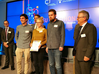
Z_GIS graduates Jakob Miksch and Martin Sudmanns (who is now part the scientific team at Z_GIS) and their colleague Karina Krampf got second place at the first
EU Datathon in Brussels for their web application
LightOnEurope. Congratulations!
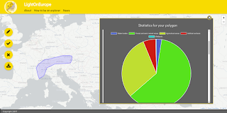 |
| Web application LightOnEurope |
The web application allows users to explore any region within Europe by simply drawing it on the map – regardless of administrative boundaries. Based on the user-defined region, the app renders an infographic which conveys relevant and easy to comprehend information on it. Currently, open data on population, landcover, mountains and climate are included. An extension with other datasets such as infrastructure and lakes, but also real-time information on the weather, etc. is envisaged. The app aims to support citizens in exploring regions and in understanding their spatio-temporal dynamics. It is also relevant for other domains such as tourism and transportation and it supports enterprises in finding attractive business sites.
The
EU Datathon 2017 – Reusing European Union open data for jobs and growth – EU Open Data Portal Datathon was jointly organised by the Estonian Presidency of the Council of the European Union and the Publications Office of the European Union.
Presenting the
LightOnEurope app, the jury emphasised the use of geospatial location to combine datasets across the borders of EU states – an approach which is familiar to the team as all three members are geographers.
More information and news on the app - including the launching date - is available on
Twitter and the
LightOnEurope-Website. For more information on the app take a look at the
presentation and the
demo video.
Contact:
lightoneureope@gmx.de


No comments:
Post a Comment